


Past Projects

GEOHuntsville and GEO Q
See us on GitHub
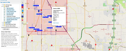
GEOHuntsville has partnered with GeoQ to enable disaster response users to:
-
quickly identify impacted areas
-
provide the ability to task and disperse response resources appropriately
-
record and report the location, well-being and tactical actions of the responders in real-time across the response spectrum.
2017 Roadmap Demonstration
Thanks to Everyone who made it a success!
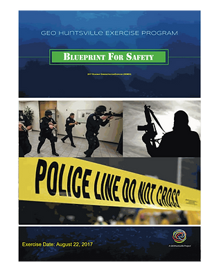
Our Blueprint For Safety Phase IV DEMEX has been completed! We were successful at testing and demonstrating Advanced Situational Awareness and Information Sharing through the Tactical Workspace.
The exercise illustrated how response to real world events can be enhanced using Sensors, Internet of Things Technologies, and "Ultra-fast Deployment" of Unmanned Aircraft Systems to bring actionable information to the Decision Maker.
Blueprint for Safety
Thanks to Everyone who made it a success!
Our Blueprint For Safety Phase IV DEMEX has been completed! We were successful at testing and demonstrating Advanced Situational Awareness and Information Sharing through the Tactical Workspace.
The exercise illustrated how response to real world events can be enhanced using Sensors, Internet of Things Technologies, and "Ultra-fast Deployment" of Unmanned Aircraft Systems to bring actionable information to the Decision Maker.
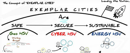
Exemplar City
Exemplar City is a model that municipal governments can follow when faced with a wide variety of challenges such as responding to a local emergency or crisis, mitigating economic impacts, dealing with workforce skill or capacity issues, or facing overwhelming infrastructure demands such as those presented during a catastrophic weather event.
TechVet Forums
Collaborative Technology Integration
TechVetTM is a streamline process designed to allow stakeholder public safety agencies within municipalities to quickly understand, integrate and procure new technologies. The Forums allow industry to present new and innovative technologies as they relate specifically to a predetermined set of requirements within the context of a predefined project or need.

February 23, 2023
GeoQ and GEOHuntsville
See us on GitHub
Who are we?
GEOHuntsville is a non-profit initiative based in the city of Huntsville, Alabama with over 400 volunteers in the geospatial community working in close collaboration to advance the geospatial tradecraft, as well as to bring awareness to our geospatial capabilities and attract collaborative investments in geospatial technology. In 2014, the group initiated the Blueprint for Safety pilot project to increase multi-jurisdictional information sharing and situational awareness among agencies and across the response spectrum in order to improve rapid disaster response. Through the developmental phases of the pilot, a concept emerged to help us share lessons and code sets, and use case documentation through a multi-city collaboration called Exemplar City. Exemplar City encourages municipalities faced with similar challenges to collaborate in an open-innovation design environment. Our collective mission is to build safe, secure, and sustainable communities.
How do we use GeoQ?
We use GeoQ to enable disaster response users to quickly identify impacted areas, provide the ability to task and disperse response resources appropriately, and to record and report the location, well-being and tactical actions of the responders in real-time across the response spectrum.
Who is using it?
Within our municipality, we have created GeoQ tactical operational workspaces for essentially every agency that responds to disasters. GeoQ is design to be used in disasters, but works equally well during steady-state operations such as special events, maintenance routines, planning, and exercises. Agencies and departments currently using GeoQ include: law enforcement, fire & rescue, medical services, emergency management, utilities, fleet services, public works, administrative agencies, dispatch, Geographic Information System (GIS) services, IT Services, and others outside of our municipality, such as civil air patrol, NGOs and volunteer organizations.
What gap does it fill?
Our community is fortunate to have the support of a very robust municipal Geographic Information System (GIS) support capability. However, we have identified the need to quickly share multi-jurisdictional response information, as well as obtain a shared situational awareness within our response community. In order to achieve this optimum level of awareness, we must first be able to report the location and well-being of our responders, and appropriately task and monitor their tactical actions within the response. GeoQ provides a great means of managing the locations of response resources (e.g. personnel, equipment and supplies) while monitoring their proximity to hazard in real-time. Our municipal GIS capability leverages GeoQ’s ability to readily take in published data. This provides a data-rich backplane of local information to the responders in the field through the tactical workspaces of each discipline, as well as across the entire response spectrum. One of the primary strengths of GeoQ is its ability to break the work down into manageable pieces (i.e. Areas of Interest AOIs), and assign the work to a cadre of predefined response resources. GeoQ not only monitors the locations of these resources, but also collects and displays the data being collected by responders. Features such as areas impacted, road closures, emergency ingress/egress routes as well as search and rescue operations, triage/transport areas and status. This data is then immediately fed back to the GIS department for further analytics as needed. Analytic output or any additional operational data created by the GIS department can then be passed back to the responder in the field through the GeoQ tactical workspace. GeoQ provides a constant response metric through visual analytics that allow emergency management personnel to monitor the response cadence, ensuring that appropriate resources are applied in the geographic areas where they are needed most. The metric is geographically displayed on the map to allow managers quick access to the pace of the response, allowing them to adjust source application accordingly.
Why we use it?
GeoQ is part of an open-source project initiated by the National Geospatial Intelligence Agency (NGA) and Mitre. NGA supports the code through their GitHub site, and as such, encourages other agencies, organizations and industry to participate in the code’s development. GEOHuntsville is a partner in this Open Innovation Community, actively participating in the development and advancement of GeoQ. Our project, Blueprint for Safety, utilizes GeoQ’s open design and combined collaborative efforts to create features that better suit our agencies’ tactical operations, resulting in the creation of features and workflows specifically tailored to meet our local operational needs.
What can we do with it?
Open source and open design allow us the flexibility to co-create with intellects we know and work with well: people working together to overcome the same challenges faced by municipalities and local governments across the country and the world. Open source allows the community to pool resources and marshal skills essential to creating a specific set of features back to the core capability. This reuse and repurpose of code has proved to be very cost efficient. People can participate, contribute and benefit from anywhere at any time, allowing them to take credit for their input, and tap their recommendations on how to improve the process.
We are part of an Open Innovation Community participating in open design
This open design is co-owned by its community
What are the next steps?
Thanks in part to this open-source initiative, GEOHuntsville is quickly moving forward to promote and extend this co-creative environment by fully operationalizing Blueprint for Safety in our community. Every day, more data is populated, and more workflows go online. Our next goal is to invite other municipalities facing these same challenges to join our collaborative forum of cities in order to share cases, lessons learned, and, yes, even code sets. To paraphrase Chris Anderson from his book Makers: “Open means we can collaborate regardless of geography...the Internet means we don’t have to rely on the person sitting in the next cubicle --we can find the best folks out there and tap into them...and now they can find us.”
Together we can build safe, secure, and sustainable communities.
LEARN MORE about what NGA is doing in the Open Source Community.
Thanks to Everyone for Making our GEOHuntsville 2017 ROADMAP Demonstration/Exercise (DEMEX) Such a Success!
March 08, 2018
Our Blueprint For Safety Phase IV DEMEX has been completed! We were successful at testing and demonstrating Advanced Situational Awareness and Information Sharing through the Tactical Workspace.
The exercise illustrated how response to real world events can be enhanced using Sensors, Internet of Things Technologies, and "Ultra-fast Deployment" of Unmanned Aircraft Systems to bring actionable information to the Decision Maker. This was a fast-paced DEMEX based on an active shooter, hostage, IED scenario and was held on Tuesday, August 22nd at the Von Braun Center in Huntsville, Alabama. Demonstrations were held in the afternoon to allow participants hands-on time with the technology and one-on-one time with the technologists and operators.
Our 2017 GEOHuntsville Demonstration and Exercise is a collaborative effort between GEOHuntsville's GEOINT, Responder, Unmanned Aircraft Systems (UAS) Working Groups and our Local Response Community.
The Blueprint for Safety Phase IV Pilot objective is to integrate current and emerging technologies into an operational environment to provide timely access to actionable information before, during, and after impact. Further objectives are to enable multi-agency information sharing in support of multi-jurisdictional rapid disaster response.
Some Phase IV Objectives include: Testing and integration of low to no-costs sensors, Discovery of new and emerging sensor, and testing the feasibility of Ultra-Fast UAS Deployment.
Problem Statement:
Lack of access to actionable information before, during, and after events severely hinders the first responders’ ability to provide safe and appropriate response to and recovery from everyday incidents. Much of this technology and the automated methods to deploy it exist today. However, communities are struggling to understand the complete picture of how fast-moving technology, automated integration, and supportive training fit together to improve information access and sharing to enhance situational awareness, increase efficiencies, lower costs, and improve responder safety.
Scope of the Exercise:
We will identify and test new and emerging sensor technologies and their integration into an information-sharing platform in order to provide a feasible technical solution to address existing (and/or remaining) response capability gaps. An active shooter, IED/bomb threat, hostage rescue scenario has been developed to provide the basis for testing in a real-world scenario that is plausible in a typical mid-sized municipality.
TechVet Forums
Collaborative Technology Integration
TechVetTM is a streamline process designed to allow stakeholder public safety agencies within municipalities to quickly understand, integrate and procure new technologies. The Forums allow industry to present new and innovative technologies as they relate specifically to a predetermined set of requirements within the context of a predefined project or need.
TechVet Forums provide an opportunity for inventors, innovators or industry to present to the proper stakeholders all at once in a structured environment, giving them an opportunity to showcase their technology and explain how it relates and integrates into the larger program. Stakeholders utilize structured feedback packages that are specifically tailor to each technology presented and how the technology relates to the project at hand. The feedback package also provides an easy rating system of how well the technology fits with the stakeholders need and/or requirement. Stakeholders provide feedback on each technology presented and are allowed to ask questions afterward.
TechVet forums are held periodically, as needed during the development of the pilot program. Typically 4-5 technologies are presented at any one TechVet Forum. Information is delivered in a very concise manner and each presentation/demonstration is limited to 12 minutes in an effort condense presentations, remove any superfluous information, and provide efficiency to the stakeholder audience. Feedback forms are gathered and reviewed by the project's technology team for suitability and ease of integration.
If the vetted technology shows promise for further testing, the technology team works with the TechVet partner to integrate the technology into the project. This is accomplished through a series of testing and integration processes and demonstrations. Once the technology reaches a sufficient integration level within the workflow of the project, a functional exercise is held with the appropriate public safety municipal agency to further integrate and test the planned workflow. One or more functional exercises may be required to further refine the technology integration with the agency practitioners and ensure successful workflow integration.
Working directly with the public safety agency through this iterative process provides enormous value to the industry partner, as it allows direct access to the practitioner that will use their product/technology as well as decision makers that will ultimately purchase and support the technology. Once successfully integrated, the technology becomes part of the use case documentation of the pilot project and is promoted through GEOHuntsville, Blueprint for Safety and Exemplar City.
At the completion of the TechVet process, the industry partner is afforded certain privileges as a TechVet Graduate and
achieves status as Preferred Provider in the Exemplar City portfolio program.
Blueprint For SafetyTM
A Game Plan for Building Safer Communities
The Blueprint for Safety Use Case portfolio is specifically designed to address the requirements needed for local municipalities to build safe, secure and sustainable communities.
As such, a critical element of the design is to adhere to guidelines and structures put in place by the U.S. Department of Homeland Security, the Federal Emergency Management Agency and other agencies to protect the well-being of United States citizens. The National Preparedness Goal identifies five mission areas in which it groups the 32 core capabilities (the distinct critical elements needed to achieve the goal).
The National Incident Management System (NIMS) is intended to be used by the whole community --the intended audience is individuals, families, communities, the private and nonprofit sectors, faith-based organizations, and local, state, tribal, territorial, insular areas, and Federal governments.
Collectively we define success as:
A secure and resilient Nation with the capabilities required across the whole community to prevent, protect against, mitigate, respond to, and recover from the threats and hazards that pose the greatest risk.
Our Current Use Case Portfolio aims to address 23 of the 32 Core Capabilities
Pilot Project: Blueprint for Safety
Regional GEOINT and Responder Working Group Pilot Project
Background: The April 2011 Tornado Super Outbreak produced 15 violent tornadoes rated EF-4 or higher (including four EF-5s) which struck the states of Mississippi, Alabama, Tennessee and Georgia. The four day period, April 25 through April 28th, marks one of the deadliest tornado super outbreaks in recent history, with a total of 358 tornadoes confirmed by the National Weather Service, claiming the lives of 324 people. In Alabama alone, 238 tornado-related deaths were confirmed by the state’s Emergency Management Agency.
An event of such magnitude has generated massive amounts of research, lessons learned, and new data. GEO Huntsville’s Geospatial Intelligence (GEOINT) and Responder Working Groups drew upon the data created from this historic event to develop a pilot project aimed at developing and integrating a new generation of current technologies, tools and methods to assist in effective cross-jurisdictional information sharing and rapid response to catastrophic events. Furthermore, the pilot sought to build efficiencies in day-to-day operations by increasing information sharing among the participating public safety agencies.
Implementation: In January 2014, members of GEO Huntsville’s GEOINT and Responder working groups launched the rapid disaster response regional pilot program known as “Blueprint for Safety”. Work is underway to discover, define and test current data collection and technology integration methods. The working group was successful in demonstrating how existing and emerging technologies can enhance geospatial intelligence gathering through information sharing platforms to improve multi-jurisdictional rapid response.
The team incorporated a variety of new on-demand, online self-service technologies and methods, one of which is a new tool set created by the National Geospatial-Intelligence Agency's (NGA) Integrated Working Group - Readiness, Response, and Recovery (IWG-R3) team for public safety use. Huntsville is utilizing the IWG-R3’s workflow tool suite of open source code that is available on GitHub. In addition, GeoQ has been used to collect geospatial features using automatic notification and manage feature collection using Structured Observation Management (SOM) from among groups of users. Finally, it has the ability to employ crowdsourcing, gamification, RFI creation and management, and the Event Page toolset to enhance information gathering and sharing during critical events. This solution, then, provides sufficient and effective transparency. Each are employing new cloud based methods built upon standards-based, open standards architectures. Multi-level access and cyber security measures are applied to actionable information to facilitate better situational awareness and understanding of events in a municipal or county government environment. The mission of the Blueprint for Safety pilot is to utilize geospatial intelligence to protect the local economy and security of the citizens to remain viable during a crisis.
The first phase of this pilot included a series of exercises and culminate in a capstone demonstration that proves the required technology integration solutions and governance framework are in place for information to be shared among multiple agencies. Future phases seek to build upon the established framework, governance, data model structures and lessons learned created in the initial phase to establish day-to-day exchange of actionable information among agencies.
Objective:
The pilot participants will work in partnership to integrate disparate technologies, platforms, and data models to enable seamless communication of data, video, and imagery in real time to improve regional preparation, protection, response and recovery activities among partner agencies.